 en
en italiano
 čeština
 Deutsch
 français
 hrvatski
 magyar
 polski
 српски
 русский
 中文
中文 中文
中文 한국어
한국어 español
Entering relative Cartesian coordinates
Entering relative Cartesian coordinates
Another, simpler method is to use relative Cartesian coordinates: you specify a location in the drawing by determining its position relative to the last coordinate you specified. To use relative Cartesian coordinates, type the coordinate values in the command bar, preceded by the at symbol (@). The coordinate pair following the @ symbol represents the distance along the x-axis and the y-axis to the next point. For example, to draw an 8.5-unit square with its lower left corner at 4,5 using relative Cartesian coordinates, start the Line command, and then respond to the prompts as follows:
Start of line: 4,5
Angle Length <Endpoint>: @8.5,0
Angle Length Follow Undo <Endpoint>: @0,8.5
Angle Length Follow Close Undo <Endpoint>: @-8.5,0
Angle Length Follow Close Undo <Endpoint>: C
|
|
|
Drawing a square using the relative Cartesian coordinates method; enter C to close. |
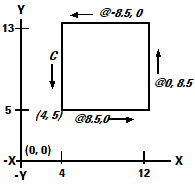
The first relative coordinate (@8.5,0) locates the new point 8.5 units to the right (along the x-axis) from the previous point of 4,5; the second relative coordinate (@0,8.5) locates the next point 8.5 units above (along the y-axis) the previous point, and so on. Entering C (for Close) draws the final line segment back to the first point specified when you started the Line command.