
 en
en italiano
 čeština
 Deutsch
 français
 hrvatski
 magyar
 polski
 српски
 русский
 中文
中文 中文
中文 한국어
한국어 español
Rubber Sheet
Ribbon: Raster Draw > Correlate > Rubber Sheet
Menu: Raster Draw > Rubber Sheet
Toolbar: Raster Draw > Rubber Sheet
Keyboard: RUBBERSHEET

Allows you to adjust an image to correct distortions in its perspective and shape.
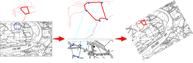
Rubbersheeting modifies an image by adjusting it so that the points you specify align as closely as possible with corresponding points in the drawing.
Is necessary to specify the points counterclockwise, sequentially, from image to vectors.
Note: through this command the image is rotated, scaled and re-placed, but is not deformed.
PROCEDURE:
- Run RUBBERSHEET command
- Press ADD POINTS button
- Select reference points (point 1 on the image, point 1 on the vectors... point 2 on the image, point 2 on its vectors... and so on sequentially, counterclockwise)
- Confirm with Enter, or Right mouse, click after last points couple selection
- Choose OK button in the dialog to terminate
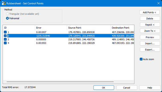
Method
Polynomial: uses control points to apply a single transformation to the entire image. However, this method does not always produce perfectly matched control points.
Control Point Table
ID: indicates the control point number.
Error: indicates the distance between the intended and actual destination points after the rubbersheet operation. This distance is also referred to as the root-mean-square (RMS) error for the control point.
Source Point: indicates the coordinates of the source point in the image.
Destination Point: indicates the coordinates of the intended destination point, after the rubbersheet operation.
Total RMS error: shows the total root-mean-square (RMS) error for the set of control points.
Buttons
Add Points: allows to add reference points on drawing.
Delete: allows to delete selected points from the list.
Repick: if some points are wrong or not optimal, it allows to re-select them.
Zoom to: zooms on drawing area about selected points.
Preview: shows a result preview about actual reference, to evaluate the precision.
Import: import a set of control points, saved in a text file (.txt).
Export: export the existing points from the Control Point Table to an external text file.
Note: When an image is modified using any tool from the Raster Draw module, changes made to the original image file may affect any other drawings that reference the same image. For more information, refer to Effect of Editing an Image.
How to...